Railroad Commissioners' Map Of Washington 1907. Washington Railroad Commission 34" x 47 1/2" sheet folded to 6" x 8 3/4" featuring a partially colored map of Washington with a … $650.00
Railroad Map Of Oklahoma Published By The State. Prepared Under The Direction Of Corporation … Corporation Commission Of Oklahoma *Map is compiled and drawn by the Engineering Department Corporation Commission.* 53" x 27" folded railroad map of Oklahoma. Colored … $800.00
Rand, Mcnally & Co.'S Dakota Territory Map Rand Mcnally & Company 26" x 20 1/4" hand-tinted map of Dakota Territory showing Indian reservations, forts and railroads. Light wear, light creasing, age-toning … $850.00
Rand, Mcnally & Co's Indexed County And Township Map Of Dakota With A New … RAND, MCNALLY & COMPANY Large 26 1/2" x 20 1/2 " full-color folding map of Dakota Territory that details all locations of railroads, counties, … $750.00
Rand Mcnally & Co.'S Indexed County And Township Pocket Map And Shippers' Guide Of … RAND MCNALLY & COMPANY First edition. 6 1/2" x 4" stiff printed wrappers, 50 pp., including advertisements for hotels, color map. Folded color map … $250.00
Rand Mcnally Pocket Maps Of Colorado For Tourists, Travelers, Shippers, General Commercial And Business … RAND MCNALLY & COMPANY Edition 1942. 8vo. 9 1/4" x 4 1/4" color pictorial wrappers, 32 pp., large folding map. The folding map is … $525.00
Report Upon The Reconnaissance Of Northwestern Wyoming, Made In The Summer Of 1873 JONES, WILLIAM A. [CAPTAIN OF ENGINEERS U. S. A.] First edition. 8vo. Brown cloth with gilt-stamping on spine, 210 pp. Numerous charts, lists, diagrams. 49 large folding trail maps … $1,275.00
Right-Of-Way And Track Map/Station Map - Lands THE UNION TERMINAL COMPANY Two 60" x 27" black and white maps of Downtown Dallas, Texas, showing the area just north of the Trinity … $2,750.00
Road Map Of Utah State Road Commission Of Utah 28" x 22 3/4" sheet folded to 36 panels. 18 panels offers a road map of Utah and with legend. … $175.00
Roads To Romance. Montana Highway Map. 1940 Montana State Highway Commission First edition. 20 1/2" x 28" sheet, folded to 30 panels. 15 panels offer a map of the Montana State … $85.00
Roads To The Clouds In Colorado THE COLORADO ASSOCIATION First edition. 8vo. 9" x 16" one sheet that folds to 9" x 4." Four panels per side. One side … $275.00
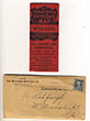
Rock Island Arsenal: In Peace And In War. With Maps And Illustrations BENJAMIN FRANKLIN TILLINGHAST 9-1/2" x 7-1/4" printed wrappers with a map of the Illinois & Mississippi Canal on the back cover. [xxxii]. Advertisements … $350.00
Sectional Map Of Colfax And Mora Counties, New Mexico EDWARD ROLLANDET First edition. 28 3/4" x 39 1/4" colored lithographic map, printed on banknote paper. An attractive and finely-executed map of … $750.00
Seeing Salt Lake City GRAY LINE MOTOR TOURS Single sheet [47 cm x 40 cm] that folds to pamphlet [23.5 cm x 10 cm]. Printed in yellow, blue … $125.00
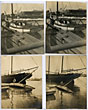
Seven Photographs Showing The 35' Sailboat "Avalon" Before And After Being Wrecked At Its … MACKENZIE, COLIN S. [PHOTOGRAPHER] This collection of seven photographs shows the sailing sloop "Avalon," built and based in Aberdeen, Washington, and owned by "Harry" … $550.00
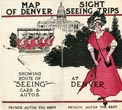
Sight Seeing Trips At Denver. Map Of Denver Showing Route Of "Seeing" Cars & … "Seeing" Denver First edition. 14 3/4" x 16" sheet folded to 16 panels. Printed in red and black. Two cover panels and … $195.00
Sketch Of General Riley's Route Through The Mining Districts July And August 1849 LT. GEORGE HORATIO DERBY First edition. Map measures 20 1/2" x 19 1/4" with title in the lower left corner. A lithograph map of … $975.00
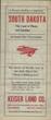
South Dakota. The Land Of Plenty And Sunshine ... Life Incomes Follow Wise Investments. … KEISER LAND COMPANY, HIGHMORE, SOUTH DAKOTA 17" x 21 1/2" sheet folded to 24 panels. Printed in red and black. A brochure touting the resources and … $300.00
Southern Pacific Company. Coast Division. The Great Pleasure Route Of The Pacific Coast Southern Pacific Company Coast Division 7" x 21" sheet on cream-colored stock folded to 12 panels each 7" x 3 1/2." 2 pictorial cover panels. … $795.00
Ten Pieces Of World War I Sheet Music VARIOUS A collection of 10 piece of sheet music produced during World War I. Pieces include: *1)* BERLIN, IRVING [WORDS AND … $150.00
The Broken Bow Country In Central And Western Nebraska, And How To Get There. … "BURLINGTON ROUTE" First edition. 8vo. Original orange, printed wrappers, 16 pp., folding map: *Map of Nebraska, 1886.,* 59 x 99 cm. (23 … $2,500.00
The Centennial Trail BRIAN KEINTZ First Edition. Large, Multiple Sheet Map. Eleven Sheets, each 19'x29'. Map imprint is 16.625" x 22.75." Each sheet shows a … $50.00
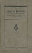
The Life Of Jim Baker 1818-1898. Trapper, Scout, Guide And Indian Fighter NOLIE MUMEY First edition. 8vo. Limited to 250 signed copies of which this is # 200. Two-tone quarter cloth and boards with … $575.00
The Life Of Jim Baker 1818-1898. Trapper, Scout, Guide And Indian Fighter NOLIE MUMEY First edition. 8vo. Limited to 250 signed copies of which this is # 200. Two-tone quarter cloth and boards with … $600.00
The Matthews-Northrup Up-To-Date Map Of The United States. Annotated Vest-Pocket Series THE MATTHEWS-NORTHRUP CO First edition. Printed stiff wrappers. Full-color map of United States, with inset map of Alaska, opens to 12" x 20". … $250.00
The New Orleans Tourist's Guide Streckfus Steamer "Capitol" 9" x 8" sheet folded to 4 panels of which two are cover panels. Front cover panel is bright color … $65.00
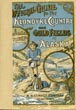
The Official Guide To The Klondyke Country And The Gold Fields Of Alaska. With … W. B. CONKEY COMPANY First edition. 8vo. Color pictorial wrappers, 296 pp., publishers' notice, frontispiece (pictures on both sides), index, maps, illustrated, portraits. Details … $750.00
The Port Of New York Authority Railroad Terminal Map Of New York Harbor. 38" x 49" color lithographed map, the legend indicating railroads, terminals and yards, waterfront terminals, Railroad passenger stations, free lighterage … $325.00
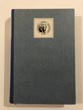
The Port Of Portland. Portland, Oregon. United States Of America / (Title Page) The … The Port Of Portland Commission First edition thus. 8" x 5" in gray cloth with printed borders and title in black on front cover. 16 … $595.00
The Rand-Mcnally Indexed County And Railroad Pocket Map And Shippers' Guide To Texas Showing … RAND MCNALLY & COMPANY First edition. 12mo. 6 1/2" x 4" brown stiff, printed wrappers, 102 pp., illustrated, advertisements, large color folding map. Large … $895.00