Dealer in Rare and First-Edition Books: Western Americana; Mystery, Detective, and Espionage Fiction
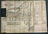
Williams Map Of N. York
WILLIAM WILLIAMS
Other works by WILLIAM WILLIAMSPublication: William Williams, 1828, Utica
Engraved by V. Balch & C. Stiles. Folded 28 1/2" x 20 1/8" colored map housed in 3 1/4" x 5 1/2" green leather-covered soft boards. Besides the map of the state, there is an inset "Profile of the Grand Ere Canal" and text describing the Erie, Champlain, Oswego, Seneca, Delaware and Hudson, and Morris canals. The right side contains nine 7 3/8” long columns with the heading, "Stage, Canal, and Steamboat Register, &tc." Those columns contain information on mileage between cities; stage routes; Erie Canal racket boats; Hudson River and Lake Erie steamboats; the population of counties as of 1825; colleges in the state of New York; Trenton Falls; rates of tolls on canals; a description of Utica; and the Welland Canal in Upper Canada. Map has a small 1/2" tear at upper right corner but not affecting any printing, minor teats at a few fold creases, covers lightly soiled and rubbed else very good.
Inventory Number: 44719


