Dealer in Rare and First-Edition Books: Western Americana; Mystery, Detective, and Espionage Fiction
The Pikes Peak Region, Colorado Springs And Manitou
COLORADO SPRINGS CHAMBER OF COMMERCE
Other works by COLORADO SPRINGS CHAMBER OF COMMERCEPublication: Privately printed, n d (ca 1925), NP
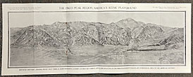
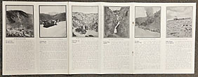
9" x 4" pictorial wrappers, 24 panels, opens to 6 panels (9" x 24"), illustrated. Opens to a 9" x 24" birdseye view map of The Pike's Peak Region, America's Scenic Playground. This is an attractive view of the region and shows all canons, Mt. Baldy, Mt. Arthur, Mt. Garfield, etc. auto roads, railroad routes, the Broadmoor, Stratton Park, Colorado Springs, etc. A nice two panel view of a canon scene in the Pikes Peak region. Views of Hidden Inn at Garden of the Gods, Ute Pass, golfing, etc. Twelve panels with each providing a sketch and view of the Palisades, Cliff Dwellings at Manitou, Crystal Park auto road, Mt. Manitou scenic incline, Ute Indian Trail to Cripple Creek, Cog Road Station on Summit of Pikes Peak, and others. Covers lightly soiled, spine lightly rubbed, two staples are missing but the panels display well. A very good, attractive item.
Inventory Number: 34544


