Dealer in Rare and First-Edition Books: Western Americana; Mystery, Detective, and Espionage Fiction


The John Hopp Mining Property, Barkerville, Cariboo, B.C
John Hopp Mining
Other works by John Hopp MiningPublication: Privately published, 1923, Cariboo, BC
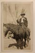
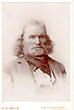
11" x 8 1/2" in black cloth with title stamped in gilt on front cover. 24 pp. of text plus 34 original photographs and four folding maps and charts. Almost all photographs measure 4 3/4" x 6 3/4" photographs are pasted directly to pages, though two 8" x 10" photographs are laid in. Original typescript documents extolling the richness of the John Hopp British Columbia mine. The John Hopp Mining Property is known for its historical significance in gold mining, particularly in British Columbia during the early 1920s. Includes photographs and maps from the mine as it produced gold in the early 1920s. Photographs are original with purple photographer's stamps on the backs. Hopp was a notable figure in the Cariboo region of British Columbia, particularly known for his involvement in mining. He managed operations at Slough Creek Ltd., which included the first shaft house, first office and first bunkhouse. His contributions were significant in the development and operation of the mining activities in the Wells-Barkerville area where he had a mine named after him. The John Hopp Mine at Lowhee Creek was a significant gold producer in the Wells-Barkerville area. His contributions were significant during the gold rush era, and his legacy is still remembered in the region. Journal contains information on the history of gold discovery in Cariboo followed by information on mining at Stouts Gulch, Lowhee Creek, Mosquito Creek, Forest Rose, Conklin's Gulch and Williams Creek. Information on estimated earnings, estimated costs, cubic yards washed, ounce yields, value of yields, values per cubic yard, actual operating expenses, improvements, and profits over operating expenses for years 1907-1924. Photographs include Stouts Gulch hydraulicing, Stouts Gulch to Lowhee Summit, Lowhee Ditch & Penstock facing Lowhee Stouts Gulch Summit, the new Lowhee Reservoir Dam construction, Lowhee Flume and Dump, Lowhee Flume and Pit, Mosquito Creek Flume, cleaning bedrock at Mosquito Creek, the building at Willow River, Ella Reservoir Dam construction, the saw mill at Jack of Clubs Lake, Forest Rose Flume, gold samples from Lowhee Stouts Gulch and Mosquito Creek, etc. 8 1/2" x 11" folding map showing placer claims, leaseholds, etc. on Williams Creek; 10" x 16" folding map showing the John Hopps Mining Properties in Barkersville District, B.C.; 18" x 22" folding map showing the Department of Mines British Columbia a Mining Divisions in 1922 and 8 1/2" x 16 1/2" folding chart showing leaves, real estate placer claims, record placer claims, crown granted land, and water records for the John Hopp Mining Property. Near fine.
Inventory Number: 45634Sold -- Contact us