Dealer in Rare and First-Edition Books: Western Americana; Mystery, Detective, and Espionage Fiction
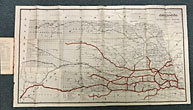
The Broken Bow Country In Central And Western Nebraska, And How To Get There. With A Sectional Map On Nebraska, Showing Towns And Railway Lines, Completed And In Course Of Construction, On August 1st, 1886
"BURLINGTON ROUTE"
Other works by "BURLINGTON ROUTE"Publication: Journal Company, State Printers, 1886, Lincoln
First edition. 8vo. Original orange, printed wrappers, 16 pp., folding map: Map of Nebraska, 1886., 59 x 99 cm. (23 1/4" x 41"), 12 miles to one inch. The map was the project of the Burlington Route for selling land. Very detailed and routes outlined in bright red. Broken Bow was to be the new center of life in Nebraska. The map is in fine condition, some splitting at the bottom two inches of the spine due to the folded size of the map, and a tiny closed tear and a few minor nicks to the rear cover fore-edge, overall a near fine copy.
Inventory Number: 47038$2,500.00


