Dealer in Rare and First-Edition Books: Western Americana; Mystery, Detective, and Espionage Fiction
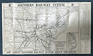
Southern Railway System Pictorial Folder And Map
SOUTHERN RAILWAY SYSTEM
Other works by SOUTHERN RAILWAY SYSTEMPublication: Privately printed, 1923 (Map), N P
First edition. 32" x 18" sheet, folded to 9" x4." One side opens to a color map of the Southern Railway System which begins in New York City and travels to many southeastern points including Mobile, New Orleans, Atlanta, Jacksonville, Palatka, Charleston, Savannah, etc. The line does travel westward to St. Louis, Memphis, and Shreveport. An inset map of Florida is present along with listings of Passenger Traffic Representatives and "Through Ticketing" arrangements. The other side consists of 16 panels that provide views of Asheville, North Carolina, Chattanooga, Tenn., Jackson Square, New Orleans, the Capitol Building and Lincoln Memorial in Washington, D. C., High Bridge on the Kentucky River, 103 miles south of Cincinnati, etc. Booklet rubbed at a few fold creases else a very good copy.
Inventory Number: 39898


![Index To Arizoniana, The Journal Of Arizona History,1960-64. COLLINS, KAREN SIKES [COMPILED BY].](/media/images/thumb/52595.jpg)


