Dealer in Rare and First-Edition Books: Western Americana; Mystery, Detective, and Espionage Fiction
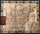
Phelp's Travelers' Guide Through The United States; Containing Upward Of Seven Hundred Rail-Road, Canal, And Stage And Steam-Boat Routes. Accompanied By A New Map Of The United States
HUMPHREY PHELPS
Other works by HUMPHREY PHELPSPublication: Ensign & Thayer, 1848, New York
First edition. 16mo. Pictorial gilt-stamped red leather covers with ornate gold borders and gold pictorials of a steam locomotive and a river steamboat on front, blind-stamped rear cover. All edges gilt, color marbled rear endpaper. 70 pp. plus large folding map: Atwood, J.M.: "Phelps's National Map of the United States, A Travelers Guide. Containing the Principal Rail Roads, Canals, Steam Boat & Stage Routes, Throughout the Union." Color outline map measuring 21 1/4" x 25." Inset of Florida, and eight inset plans of American cities; decorative border with portraits of the presidents and other historic American figures, and the great seals of the thirty states. With the 1847 edition, the text for Phelps & Ensign's Traveller's Guide... was expanded, and issued under Phelps' name alone. The old map introduced in 1838 has been replaced with a new one, finely engraved, by J. Atwood. The map extends as far west as east Texas. A desirable copy in very good condition.
Inventory Number: 46799


