Dealer in Rare and First-Edition Books: Western Americana; Mystery, Detective, and Espionage Fiction
New Brunswick. Canada's Unspoiled Province
New Brunswick Government Bureau Of Information And Tourist Travel
Other works by New Brunswick Government Bureau Of Information And Tourist TravelPublication: New Brunswick Government Bureau of Information and Tourist Travel, 1929, Fredericton
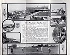
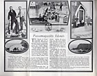
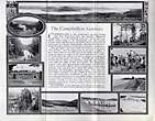
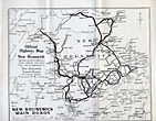
9 1/24" x 11" tri-folded and housed in 9 1/4" x 4 1/4" colorful pictorial covers. 28 pp., triple column text, maps, illustrations, table of distances. Overview of New Brunswick followed by one page of text on the St. Stephen Gateway, Passamaquoddy Islands, St. Andrews-by-the-Sea, St. Goerge and Lake Utopia, Saint John, the Kennebecasis Valley and St. Martins, Sussrx, Albert County, Moncton, Westmorland County, along the East Coast, Miramichi, Bathurst and Gloucester County, the Campbellton Gateway, Edmundston, Grand Falls and the Tobque, the Woodstock Gateway, the Saint John River Valley, Fredericton, Grand Lake and Washademoak. Surrounding each black of text are numerous black and white photographs depicting that which is written about. 71/2" x 7"sketch map of New Brunswick indicating main automobile roads into New Brunswick. Official Highway Map of New Brunswick showing numbered highways, routes, mileages. 9 1/4" x 11" black and white map showing New Brunswick main roads. Edges of pages lightly worn. Spine of covers rubbed and with light wear to the extremities. Very good. A nice item.
Inventory Number: 39461


![Tseyi. Deep In The Rock, Reflections Of Canyon De Chelly TOHE, LAURA [TEXT BY]](/media/images/thumb/50126.jpg)


