Dealer in Rare and First-Edition Books: Western Americana; Mystery, Detective, and Espionage Fiction
National Railways Of Mexico, Workers Administration. Visit Mexico's Byways. Oaxaca. Patzcuaro. Uruapan. Jalapa. Direct Rail Connections. Time Table Folder. Issued May 20, 1939
National Railways Of Mexico
Other works by National Railways Of MexicoPublication: Privately printed, 1939, NP
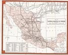
9" x 8," in orange and brown printed wrappers, folded in half. 24 pp. including wrappers. Double column text. Illustrations. Maps. General information for the traveler followed by three pages of information on Mexico City and the vicinity. One-page street map of Mexico City. At center is a system map of the National Railways of Mexico from El Paso to Yucatan and showing all principal stations. Also at center is a 5" x 8" map showing the railway system from Aguascalientes and Guadalajara down to Puero Mexico. Eleven pages of time schedules followed by a listing of fares to Mexico City via rail and pullman. Light soiling to wrappers. Very good.
Inventory Number: 51614$195.00


![Oklahoma. Lock, Stock And Barrel. (Cover Title) RENAS, TYRELL "TOODLES" [COMPILED BY]](/media/images/thumb/39739.jpg)


![Useful And Practical Hints For The Settler On Canadian Prairie Lands /(Title Page) Useful And Practical Hints For The Settler On Canadian Prairie Lands And For The Guidance Of Intending British Emigrants To Manitoba And The North-West Of Canada. With Facts Regarding The Soil, Climate, Products, Etc., And The Superior Attractions And Advantages Possessed, In Comparison With The Western Prairie States Of America SPENCE, THOMAS [CLERK OF THE LEGISLATIVE ASSEMBLY OF MANITOBA]](/media/images/thumb/39678.jpg)


