Dealer in Rare and First-Edition Books: Western Americana; Mystery, Detective, and Espionage Fiction
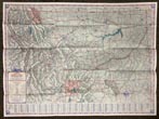
Montana Highway Map. 1941
Montana State Highway Commission
Other works by Montana State Highway CommissionPublication: Montana State Highway Commission, 1941, Helena
First edition. 20 1/2" x 28" sheet, folded to 30 panels. 15 panels offer a map of the Montana State Highway System, printed in blue, red and gray ink and showing paved, improved, graded roads and roads under construction. Opposite 15 panels offer a two cover panels, printed in yellow and black and showing a young woman on a running horse with cowboys, Indians, and a covered wagon behind and with 5 cars on a highway shown below the illustration. 13" x 10" map of Waterton-Glacier Peace Park and a 13" x 10" map of Yellowstone National Park, both printed in yellow and black and showing main, secondary and connecting roads, interstates and trails. Opposite panels also offer a mileage table and brief messages from the state governor and state highway department. Near fine.
Inventory Number: 49317


