Dealer in Rare and First-Edition Books: Western Americana; Mystery, Detective, and Espionage Fiction


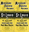
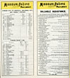

Missouri Pacific Railway. St. Louis To All Points West. Chair Cars Free - Fast Mail Route
Missouri Pacific Railway
Other works by Missouri Pacific RailwayPublication: Missouri Pacific Railway, 1892, ST LOUIS
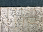
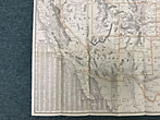
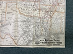
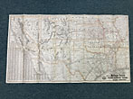
17" x 32" sheet folded to 32 panels. 2 cover panels printed in yellow and black along with14 panels of schedules. Opposite 16 panels offers a striking map of the Missouri Pacific and St. Louis, Iron Mountain and southern Railway and Connections, with hand-colored outlines of the states. Interestingly, 2/3 of the map show no rail lines connecting the Missouri Pacific network. Map extends from Alabama, Tennessee and Illinois in the east to the Pacific Ocean along the California coast. Light wear to folds and extremities along with stamp from the Christian Union Recreation Department in upper right corner of cover panel. Very good.
Inventory Number: 48380Sold -- Contact us