Dealer in Rare and First-Edition Books: Western Americana; Mystery, Detective, and Espionage Fiction
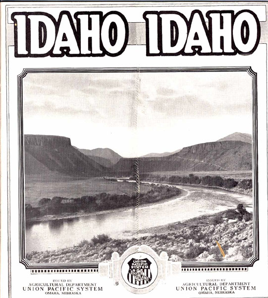
Idaho
Agricultural Department Union Pacific System
Other works by Agricultural Department Union Pacific SystemPublication: Agricultural Department Union Pacific System, 1924, Omaha
8-1/2" x 7-3/4" pictorial wrappers. 96pp. Illustrations. Double page black and white map entitled "UNION PACIFIC SYSTEM - Union Pacific Railroad Co., Oregon Short Line Railroad Co., Oregon-Washington R.R. & Nav. Co., Los Angeles & Salt Lake R.R. Co., St. Joseph & Grand Island Ry. Co., AND CONNECTIONS OVER WHICH THROUGH TRAINS AND THROUGH SLEEPING CARS ARE OPERATED" at center of pamphlet. States shown in full or partially are Washington, Oregon, Idaho, Montana, North Dakota, South Dakota, Nebraska, Wyoming, California, Nevada, Utah, Colorado, Arizona, New Mexico, Texas, Oklahoma, Arkansas, Louisiana, Mississippi, Fla., Alabama, Tenn., Ky., Missouri, Kansas, Illinois, Indiana, Minnesota, Iowa, Mich., Wisconsin, also shown Lake Superior, Lake Michigan, the Gulf of Mexico, the Gulf of California, Pacific Ocean, Mex., and the Dominion of Canada. Also a 7-1/2" x 5" black and white map entitled "IDAHO--AN INTERMOUNTAIN EMPIRE." Illustrations include crops, grains, pigs, a sugar factory, potato storehouses, irrigation, dairy cows, fruits, various breeds of sheep, a school, the Arrowrock Dam, et. al. Briefly states on the inside of the front wrapper "Idaho Facts" such as the population, the total area, the pounds of wool that Idaho shipped in 1923, Shoshone Falls, the value per capita of all Idaho products, from forests, mines and fields, is about $300 annually, etc... Brief descriptions of the climate, farm labor in Idaho, irrigated farming, health conditions in Idaho, forest reserves, Idaho roads, horticulture, dairying in Idaho, water power, agricultural colleges and scientific farming, Idaho schools, transportation, Southern Idaho to include the following counties Ada, Adams, Bannock, Bear Lake, Bingham, Blaine, Boise, Bonneville, Butte, Camas, Canyon, Caribou, Cassia, Clark, Custer, Elmore, Franklin, Fremont, Gem, Gooding, Jefferson, Jerome, Lemhi, Lincoln, Madison, Minidoka, Oneida, Owyhee, Payette, Power, Teton, Twin Falls, Valley, Washington, Northern Idaho counties include Benewah, Idaho, Kootenai, Latah, Lewis, Nez Perce, Shoshone, Malheur County, Oregon which is located on the boundary line between Eastern Oregon and Western Idaho.
Agricultural publications are listed for the new settler in Idaho and may be obtained from three Agents. On the inside of the rear wrapper are listed the "Representatives of the Union Pacific System." Two pages devoted to "The Railroad a Business Builder." The rear wrapper has an illustration of the Milner Dam along with the name and address of a Supervisor of Agriculture from the Agricultural Department of the Union Pacific System to help industrious men and women to become farm owners. Vertical crease to front wrapper, tiny closed tear to fore-edge of rear wrapper else an extremely informative booklet. A nice copy.