Dealer in Rare and First-Edition Books: Western Americana; Mystery, Detective, and Espionage Fiction
Geography Of Louisiana To Accompany Mitchell's Intermediate Geography
E. H. BUTLER AND COMPANY
Other works by E. H. BUTLER AND COMPANYPublication: EH Butler and Company, Publishers, 1890, Philadelphia
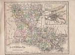
First edition. Quarto. 12 1/4" x 9 3/4" in sewn, printed wrappers. 12 pp. (including covers). Illustrations, map, double columns, footnotes. Page 2 offers a full-page color map of Louisiana showing counties, cities, railroads, etc. Inset at upper right corner is a 3 1/2" x 3 1/2" black and white map showing New Orleans. Offers questions about the map, vocabulary, and much information about Louisiana to include information on the coastline, lakes, climate, various rivers, vegetation, soil, minerals, manufacturers, government, railroad, industries, education, penal institutions, state charities, cities and towns, religion, history, etc. Illustrations show a levee at New Orleans, St. Charles Street in New Orleans, Tulane Hall, Louisiana's Institution for the Deaf and Dumb and the Blind in Baton Rouge, etc. A light old water stain to the top corner of the front cover, a light corner crease to the top edge of the last page and the rear cover along with a few minor nicks to the fore-edges and extremities, else a very good copy.
Inventory Number: 44016


![Report Upon The Reconnaissance Of Northwestern Wyoming, Made In The Summer Of 1873 JONES, WILLIAM A. [CAPTAIN OF ENGINEERS U. S. A.]](/media/images/thumb/52733.jpg)


