Dealer in Rare and First-Edition Books: Western Americana; Mystery, Detective, and Espionage Fiction
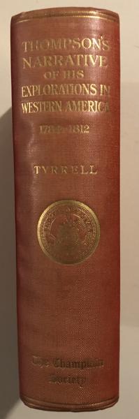


David Thompson's Narrative Of His Explorations In Western America, 1784-1812.
JOSEPH B.--EDITOR TYRRELL
Other works by JOSEPH B.--EDITOR TYRRELLPublication: The Champlain Society, 1916, Toronto
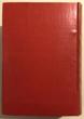
First Edition. Original Red Cloth, with gilt-imprint on spine. TEG. #235 of a Numbered Edition limited to 500 copies, less than 400 of which reached private hands. xcviii, 582pp.+viii List of Members and Subscribing Libraries. Three fold-out color plates depicting Thompson's sketches of mountain ranges in Montana and British Columbia, plus 18 additional Plates. 5 Maps, 4 of which are large folding maps in pocket-at-rear, as issued. Preface. Introduction. "David Thompson's Itinerary in North-Western America, 1785-1812". Bibliography. Index. An Englishman, David Thompson came to Ft. Churchill on Hudson's Bay in 1784, at the age of 14. Employed by the Hudson's Bay Company as a trapper and trader, Thompson was as much interested in mapping and exploration as he was in fur trading. He became a wilderness man, exploring and trading throughout the Canadian West and the northwestern part of what is now the United States. He learned surveying and explored and opened routes between Canadian posts. In 1797, Thompson joined the North West Company, conducting a major mapping tour west of Lake Superior. He traveled throughout northern Minnesota, the Red River region, and what later became Dakota Territory, visiting the Mandan Villages in January, 1798. In 1807, he crossed the Rocky Mountains and built the first trading post on the Upper Columbia. Thompson thoroughly explored the Columbia River basin over the course of the next 4 years. He gave the name, via his French Canadians, to the Nez Perces, introduced firearms among the various tribes, and was very active for several seasons as trader, as well as explorer. In his continuing efforts to establish trade and locate new fur country, Thompson reached the mouth of the Columbia in July, 1811, where he found the Astorians in the process of constructing their post. He returned to Montreal in 1813, and one year later produced a map of truly exceptional importance. Of Thompson, the outstanding scholar, Elliott Coues wrote in 1897, "(He) explored and charted an important and previously unknown region. Thompson was the first white man to follow the Columbia from its source to its mouth. He mapped with sextant and compass, traveling fifty thousand miles on foot, horseback, and canoe. The Indians called him Koo-Koo-Sint (man who looks at the stars)..."The greatest geographer of his day in British America, and maker of what was then by far its greatest map." In his monumental work, Mapping The Transmississippi West, Carl Wheat wrote of Thompson and his maps, "As cartographer and explorer he was second to no man of his period..."One of the greatest maps ever drawn, a magnificent cartographic monument to its maker." A manuscript copy of Thompson's early map of the Upper Missouri was found among William Clark's papers in the Library of Congress on the back of which is written, "This Belongs to Capt. Lewis". The maps value to Lewis and Clark was that it was the first map to accurately locate the Mandan and Arikara villages. The narrative of David Thompson's exploration and his great maps are produced here in one massive volume. This important first edition is the most highly sought publication of The Champlain Society. Thompson's narrative is brilliantly edited by Joseph B. Tyrrell, with the resultant work being of great importance, complete with maps and plates illustrating Thompson's exploration. Of this work, Wright Howes states, "Most important contribution to western history and exploration published in the twentieth century, Thompson's operations on the Upper Columbia and Spokane rivers, in 1807, gave color to England's Oregon claims." Slight sunning to spine, else an exceptionally clean, tight, bright, fine, uncut copy of this rare and important work. Color fold-out plates and maps in fine, bright condition. Protected in a Half-Leather, Clamshell case, with title, author, and year of publication in gilt on spine. Avidly-sought and rarely-offered, this important work is a cornerstone for any collection of early Western exploration and cartography. Also included is Joseph Tyrrell's rare, earlier work, A BRIEF NARRATIVE OF THE JOURNEYS OF DAVID THOMPSON, IN NORTH-WESTERN AMERICA. Printed by The Copp, Clark Company, Limited, General Printers of Toronto, in 1888. 28pp. in Printed Wrappers. A little-known, early, and scholarly account by Tyrrell of Thompson's great manuscript journals. The main body of this work is a precise itinerary and chronologically followed movements of Thompson throughout the western country. Appended is a five page table locating 83 forts and trading posts which Thompson visited and described. A very good copy of this rare and fragile work. A Presentation Copy: "With the Author's Compliments" in ink along top edge of front wrapper. Both rarities housed in the same Clamshell case.
Inventory Number: 53630$5,500.00
![Santa Fe Trade ROSSI, PAUL A. [EDITOR]](/static/basic_cms_store2/img/CoverNotFound3.jpg)