Dealer in Rare and First-Edition Books: Western Americana; Mystery, Detective, and Espionage Fiction
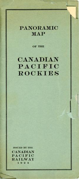
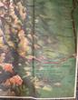
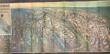
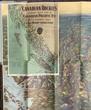
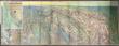
Canadian Rockies Showing Main Line Of Canadian Pacific Railway With Branch Lines & Steamship Connections
CANADIAN PACIFIC RAILWAY
Other works by CANADIAN PACIFIC RAILWAYPublication: Privately printed, 1924, N P
A lovely color pictorial map (17" x 45.5", folding to 8.5" x 4") and showing the route of the Canadian Pacific from Calgary and Macleod in the east to Vancouver and Seattle in the west, as well as several shorter branch lines. Map has a split at one fold, but is otherwise in fine condition. Over-sized folder has chips and tears. Includes excellent detail of topography, with different mountain ranges identified and names and elevations given for many individual peaks. Parks are also identified, as are numerous small towns. Steamer lines are shown in Kootenay Lake, Arrow Lake, Okanagan Lake, and the Straits of Georgia and Juan de Fuca. There is a table of distances at the lower right and an inset map of the coastline from Seattle to Skagway, Alaska.
Inventory Number: 53471$400.00

![Central And Western Nebraska And The Experiences Of Its Stock Growers. (Cover Title) ALLAN, J. T. [PREPARED AND COMPILED BY]](/media/images/thumb/50300.jpg)