Dealer in Rare and First-Edition Books: Western Americana; Mystery, Detective, and Espionage Fiction
1904 Railroad Map Of Ohio, Published By The State
MORRIS, J.C., COMMISSIONER OF RAILROADS AND TELEGRAPHS, COLUMBUS, OHIO]
Other works by MORRIS, J.C., COMMISSIONER OF RAILROADS AND TELEGRAPHS, COLUMBUS, OHIO]Publication: The Columbus Lithograph Company, 1904, Columbus
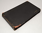
Map is prepared under the direction of J.C. Morris, Commissioner of Railroads and Telegraphs, Columbus, Ohio. 28 1/2" x 32 1/2" folded linen-backed railroad map of Ohio. Color-coded routes of all major railroad lines operating in the state. Lines include Baltimore & Ohio; Cincinnati, Hamilton & Dayton; Cleveland, Cincinnati, Chicago & St. Louis; Erie; Lake Shore & Michigan Southern; Michigan Central; New York, Chicago & St. Louis; and the Pennsylvania Company. Map shows towns, county seats, canals, coal lands, tunnels, list of electric railways, telegraph companies, sleeping car companies, state institutions, hospitals, industrial schools, universities, public county institutions, and steam railroads. Attractive locomotive and train vignette at lower corner of map. Map is folded and bound into original black cloth covers with lettering stamped in gilt and blind-stamped border.
Inventory Number: 41303
![1904 Railroad Map Of Ohio, Published By The State MORRIS, J.C., COMMISSIONER OF RAILROADS AND TELEGRAPHS, COLUMBUS, OHIO]](/media/images/large/41303.jpg)


